Instead of a Carpathian Desert: How Can We Retain Water?
It Is Not Just a Matter of Capricious Weather
Drying lakes, low river levels, critically dry soils, declining crop yields and increasingly frequent vegetation fires: all of these are now visible in Hungary as well. We tend to explain them solely by low precipitation or climate change. The decisive role of global processes is beyond dispute, but the condition in which our own landscapes encounter these changes is just as important.
As an engineering community, we see every day that decisions about shaping the environment determine how a region functions for decades. Although conventional water management is not CÉH's primary field of expertise, landscape desiccation, extreme weather and water scarcity have become issues affecting society as a whole. As a responsible company and as engineers, we cannot remain silent about them, and our clients expect us to provide solutions.
Our aim is not to put a ready-made water management plan on the table. We want to draw attention to the fact that water scarcity is not merely a meteorological problem: rivers, soil, groundwater resources, vegetation and land use form a single system. There is therefore no simple or quick solution. Only a complete change in perspective, long-term thinking, and many responsible decisions by investors and land managers can prevent further deterioration and even improve the situation.
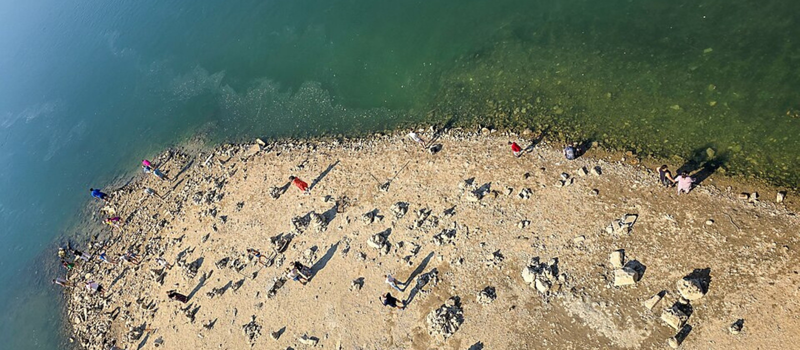
The Danube in Budapest, 19 August 2026. Photo: Szilas / Wikimedia Commons, CC BY 4.0.
The Story Began Around 150 Years Ago
The river regulation projects launched in the mid-19th century were major engineering achievements of their time: their goals were to curb flooding, improve transport and increase the area of cultivable land. Yet the intervention transformed more than floods alone. Rivers were confined between embankments, bends were cut off, marshes and wetlands were drained, and large estates replaced forms of land management in river valleys that had coexisted with flooding.
The figures clearly show the scale of the intervention. Regulation based on the plans of Pál Vásárhelyi reduced the length of the Tisza from approximately 1,420 kilometers to 962 kilometers: more than one hundred bends were cut off, shortening the river by a total of 458 kilometers and leaving behind around 600 kilometers of oxbow lakes. The shorter, straighter channel created a steeper gradient and faster runoff: a flood wave that once lasted as long as two months can now pass through the country in one or two weeks.
Lowland water management continued with the construction of inland drainage canals. Hungary's canal network now extends for nearly 48,000 kilometers, making it longer than the country's entire road network!
A consistent land-use paradigm lay behind all of this: rapidly draining water, converting the land thus released to arable use, and suppressing the natural movement of water as completely as possible. This system shaped the country for a century and a half. In today's warmer and drier climate, however, we can see not only its benefits but also the cumulative loss of water it causes.
This system can be useful during floods or periods of excess inland water. But if its primary long-term function is to drain the landscape, then rainfall and flooding during wetter periods cannot replenish the soil and groundwater reserves. The purpose of the embankment and canal system must therefore be reassessed region by region: where protection is indispensable and where the landscape-drying effect should be reduced.
A River Is More Than Its Channel
A river is not merely the water between its two banks; it encompasses the entire valley: side branches, floodplains, oxbow lakes, soil and the groundwater system. The Tisza and its tributaries once received water from the landscape and returned some of it during floods. Shallow inundations left behind sediment and fertile soil that stored moisture until the next dry period.
When we separate a river from its valley, this two-way relationship ceases. During low-flow periods, the deepening channel drains groundwater from the surrounding areas ever more efficiently: instead of replenishing the landscape, the river merely draws water from it. Channel incision, falling groundwater levels and drying floodplains become mutually reinforcing processes.
The conclusion is therefore clear: the river should not be cut off from its valley; instead, built-up areas and vital infrastructure should receive targeted protection. Where land use allows, the river must once again be given room for shallow, spreading floods. This slows runoff, prevents further channel incision and restores the replenishment of the soil.
There Was Never Any Surplus Water on the Great Hungarian Plain
The vitality of Hungary's lowland landscapes did not depend solely on locally occurring precipitation. Periodic river flooding, high groundwater levels and evapotranspiration from wetlands played decisive roles in the water balance of the Great Hungarian Plain. The landscape preserved the surplus from wetter years in the soil, peatlands, marshes, shallow depressions and underground reserves.
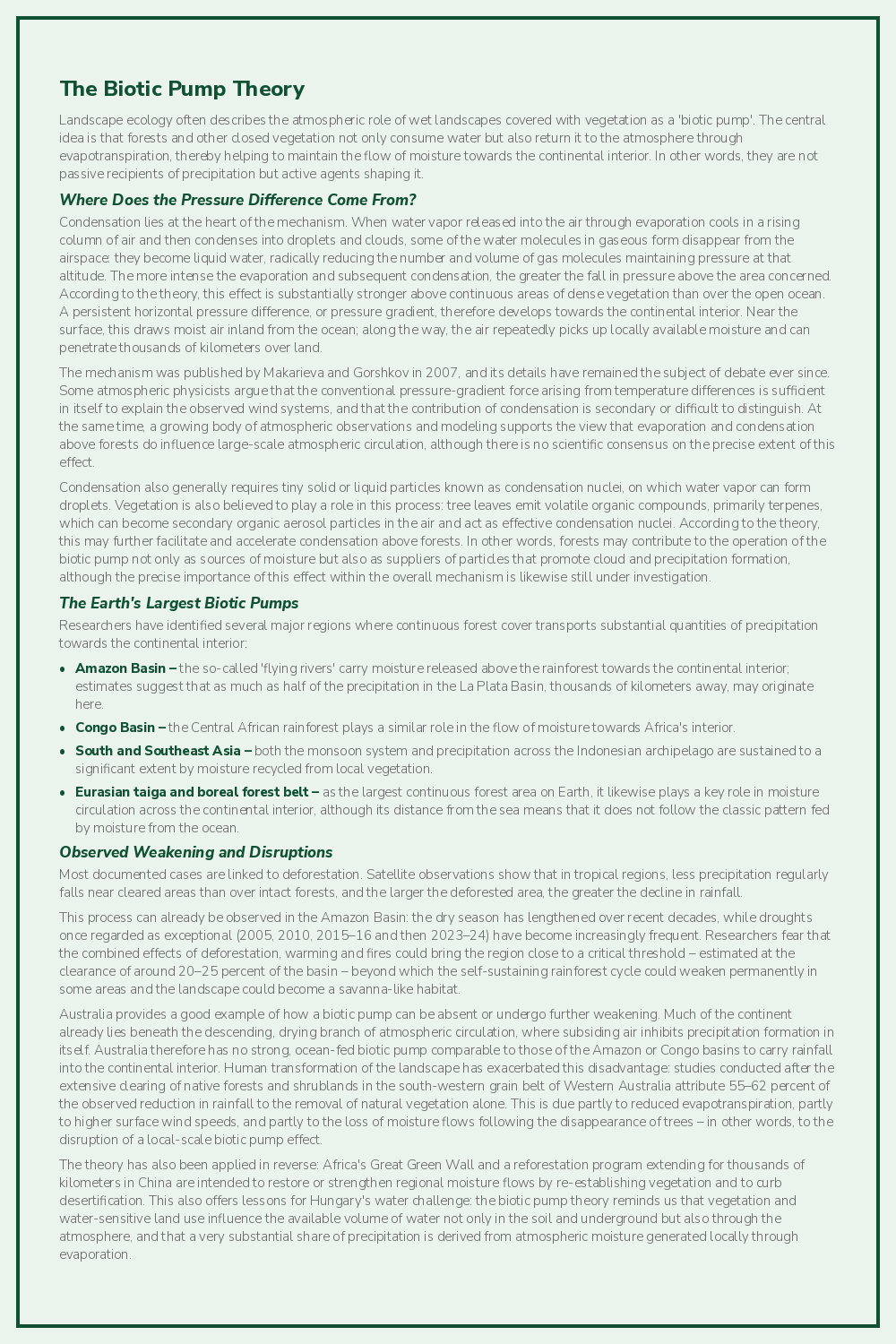
Evapotranspiration from vegetation and soil is also part of the atmospheric moisture cycle. Landscape ecology often describes this as a 'biotic pump': a moist landscape covered with vegetation not only consumes water but also returns it to the atmosphere and helps maintain the flow of moisture towards the continental interior. The precise atmospheric mechanisms remain the subject of scientific debate, but there is no dispute that large-scale drainage, declining soil moisture and changes in vegetation also alter the local and regional water cycle.
An open water surface does not in itself create a rainy climate. If it did, the surroundings of the Caspian Sea, the former Aral Sea or the Red Sea region could not be dry, and proximity to Lake Balaton would automatically bring abundant rainfall. Open water evaporates intensively, but the moisture originating from it does not necessarily fall back as rain in the same place.
Homokhátság: The Breakdown of a Water-Conserving Landscape
It is easy today to assume that the Homokhátság has always been naturally dry and water-scarce. Although it never had natural watercourses, it was in fact a closed-drainage landscape system capable of retaining the precipitation of wetter years for long periods.
Precipitation infiltrated the higher sand ridges, which were once typically open or sparsely vegetated. The water reappeared in depressions between the dunes, where it sustained peatlands, wet hollows, marsh meadows and saline lakes. Natural standing waters once numbered in the thousands on the Homokhátság; today, not even a fraction of them remain.
The system broke down from several directions. A network of 8,000 kilometers of canals connects local low points and drains water that had previously remained in place out of the landscape – in an area where natural watercourses had never existed. Much of the sandy grassland was ploughed up, while water-intensive timber plantations appeared at higher elevations. Infiltration declined, vegetation's water consumption increased, and the wet depressions that had previously stored reserves from wetter periods and made them available to wildlife disappeared, all at the same time.
The history of the Danube Valley Main Canal between the Danube and Tisza is equally telling. Local people have called it the 'Curse Canal' for generations: it was built in the first half of the 20th century to drain marshes and reclaim land, yet today we are trying to use the same network to retain water during dry periods. This clearly demonstrates how difficult it is to transform a system designed for drainage into a genuine water-retention network after the fact.
The Effects of Evaporation
Surface water is not the starting point of water retention but its final, visible stage. Water that the soil can no longer absorb appears in lakes and rivers; the soil and the groundwater system therefore play a decisive role in the formation and persistence of surface waters. When these landscape reserves are depleted, surface waters also begin to recede and eventually disappear.
The former abundance of water in the Tisza Valley was not due to sufficient precipitation every year, but to shallow floods regularly replenishing the soil – the largest and least expensive reservoir, and one directly accessible to plants. Open water surfaces, by contrast, are directly exposed to sunlight, wind and heat: in Hungary's climate, a shallow reservoir 1.5–3 meters deep may lose through evaporation an amount of water equal to its entire volume in two to four years. This does not mean that it empties from one day to the next; it means that maintaining its stock requires repeatedly adding more water than can be withdrawn from it.
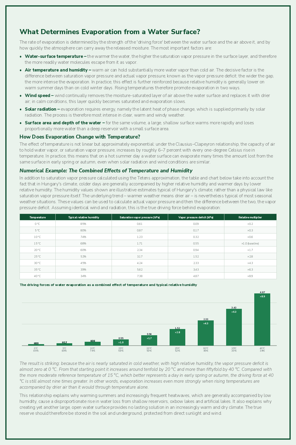
Although the water lost at each of the several dozen run-of-river barrages built almost continuously along the Danube in Germany and Austria, and at Slovakia's Gabčíkovo Hydroelectric Power Station, may be relatively small in principle, their combined effect is already very significant. This is due to the increase in water surface extending over hundreds of kilometers and to the evaporation-enhancing effect of higher summer water temperatures caused by slower flow.
The long-term water supply of the Great Hungarian Plain therefore cannot rely exclusively on shallow reservoirs with open water surfaces and irrigation from them. Such reservoirs can reduce flood peaks and store water temporarily, but most water must be retained in the soil and underground before it ever reaches a river channel or lake. Irrigation is indispensable for certain crops, but it cannot make every area suitable for cultivation that disregards the landscape's natural characteristics. Keeping a permanently desiccated landscape productive through continuous water replenishment entails high costs and energy demand and, if irrigation is poorly designed, may also cause salinization.
The Italians go even further than we do in this respect: in 2025, rice was grown on a total of approximately 235,450 hectares in Italy, the overwhelming majority of it in the Po Valley. Around 117,725 hectares were in Piedmont and a further approximately 90,000 hectares in Lombardy, meaning that nearly 90% of Italy's rice fields are located here. This makes Italy by far Europe's largest rice producer, accounting for roughly half of the EU's rice output, or around 1.4 million metric tons per year, irrigated with water from the River Po, which is drying out increasingly each summer. Apparently, truly good risotto requires sacrifices…
2026: The Shortage Is Now Visible in the Rivers
According to data from HungaroMet Nonprofit Zrt., Hungary's national meteorological service, the summer of 2026 was the driest since measurements began at the start of the 20th century. Average national precipitation was just 74.1 millimeters, barely 36 percent of the usual amount, while the mean summer temperature was 2.6 °C above the 1991–2020 climate average. This can no longer be dismissed as a statistical fluctuation; it is a changed climate.
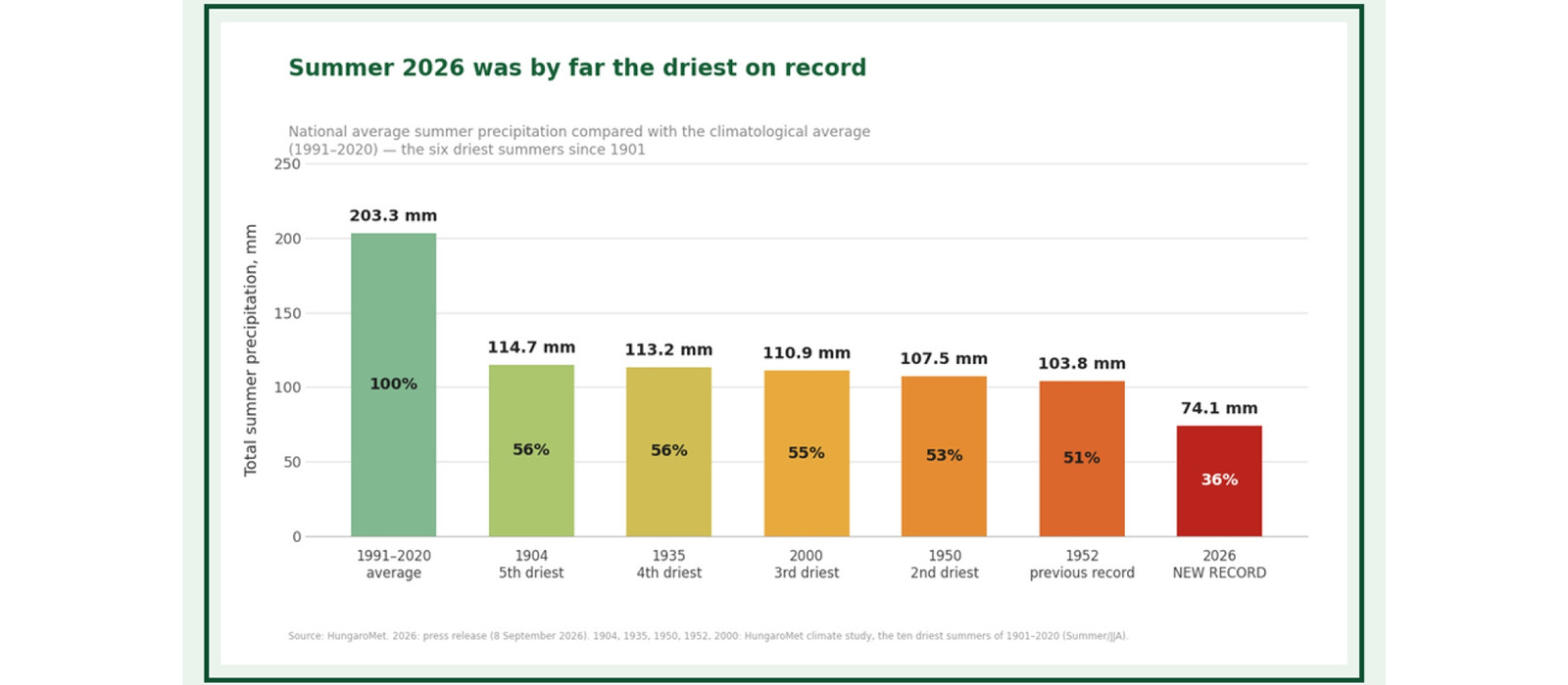
The summer of 2026 was not only drastically drier than the climatological average, but also drier than the previous record set in 1952. Its total summer precipitation was almost 30 millimeters below the 103.8 millimeters measured that year, meaning that we received only three quarters of the rainfall recorded in what had previously been the driest summer. All three summer months were affected by the precipitation deficit: June received 45 percent of the average, while July and August received only 26 percent. Summer was record-dry across around 60 percent of the country, and the driest monitoring station, in the Nagykőrös area, recorded barely 20 millimeters of precipitation over three months.
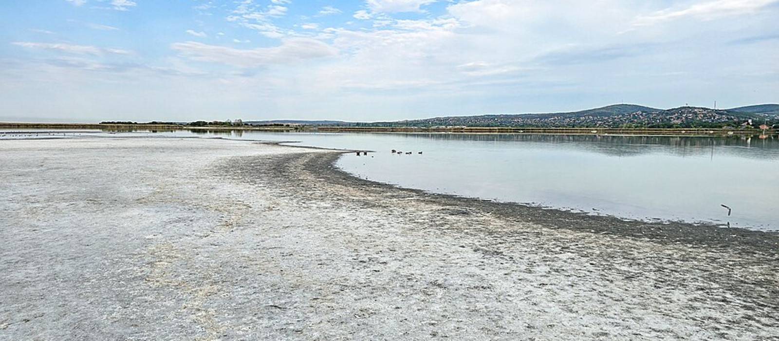
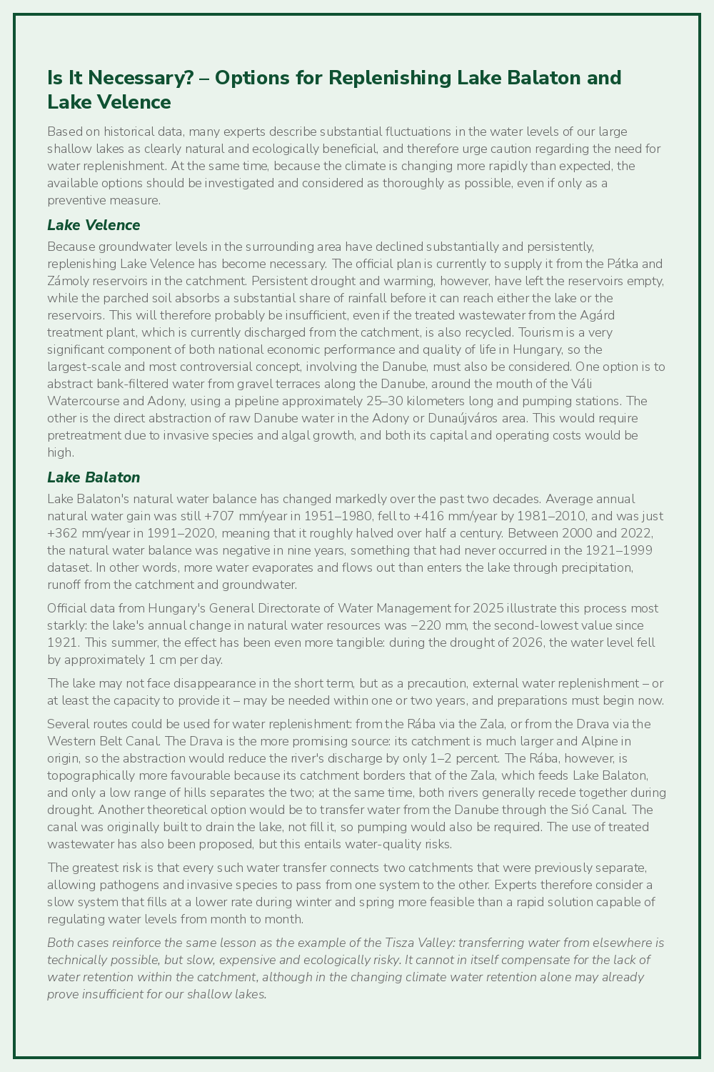
The severity of the drought is also clearly illustrated by this summer at Lake Tisza, which causes very substantial evaporation losses. During the first eight months of the year, inflow to the reservoir amounted to only around one quarter of the quantity recorded in an average year. In August, its water level was lowered to the critically low level of 610 centimeters in order to safeguard Szolnok's water supply. The operators therefore introduced an emergency operating regime: the upstream water level at the Tiszalök barrage also had to be gradually reduced to 400 centimeters; restrictions were imposed on flows transferred onward from Kisköre towards Szolnok and available for transfer to the Körös Valley; and certain abstractions for irrigation were suspended. The case of Lake Tisza demonstrates in itself that even a genuinely large reservoir cannot provide protection against a summer with persistently low inflows.
In the summer of 2026, exceptionally low flows also developed on several other rivers in the Tisza catchment. On sections of the Kraszna, the Berettyó, and the Sebes-Körös, Fekete-Körös and Fehér-Körös, discharge fell to a fraction of the long-term July average and flow continuity was interrupted in some places. This is especially alarming because these rivers are equipped with numerous reservoirs, barrages and water-control structures both in Hungary and on the Romanian side of the border. On their own, these structures were unable to prevent critical water scarcity; indeed, acting as large evaporating trays, they aggravated it. This clearly shows that further regulation or damming of a river channel does not create new water. The seriousness of the situation is illustrated by the fact that summer water replenishment of the Körös rivers effectively took place against the gradient: water management specialists used pumps to lift water originating from the Tisza from the Békésszentandrás barrage to the higher Békés barrage, so that the region's water supply could be maintained from there via the Élővíz Canal. In other words, although several barrages stand along the river, they could not replace the missing water. Instead, energy had to be used to move water artificially 'uphill' when the river would previously have carried it naturally downstream.
By contrast, the less modified, meandering section of the Maros below Arad appears as a striking green corridor through the surrounding agricultural landscape, raising the question of how much more resilient a river valley can be when the connection between the channel, floodplain and vegetation remains largely intact. Although every tributary in Arad County had dried up, at the time of writing the Maros was carrying a greater discharge at Szeged than the Tisza.
Creating additional 'Lake Tiszas' therefore cannot be a universal answer to water scarcity on the Great Hungarian Plain. The complete water balance of existing reservoirs, including the Kisköre Reservoir, their ecological benefits and their effects on downstream reaches must be reassessed periodically. Reservoirs are justified where they reduce flood peaks, provide drinking, agricultural or industrial water supplies, support important tourism destinations, or form part of a demonstrably sustainable water balance. But we cannot regard them as though they created new water resources. The same applies to artificially replenishing oxbow lakes: if water is pumped from a river's low-flow reserves into a large, shallow and intensely evaporating surface, this does not necessarily leave more water in the landscape as a whole.
The risks posed by a drying landscape are also illustrated by the July 2026 fire in the Bugac forest reserve: persistently low soil moisture makes not only agriculture but also forests, settlements and infrastructure more vulnerable. Since then, fires have broken out daily in many different parts of the country, although fortunately they have so far been contained effectively.
A similar but even larger event struck Vojvodina: a fire that broke out on the Deliblato Sands in August 2026 burned for weeks and ultimately destroyed nearly 4,000 hectares, including more than 3,100 hectares of forest, in a Pannonian sandy-steppe habitat comparable to some of Hungary's most valuable sites. Experts say that some burnt forest areas could take decades to recover, if restoring them in their previous form is worthwhile at all.
Europe's 'Water Towers' Are Disappearing Too
Changing local land use cannot stop global warming on its own. Since 1850, the glaciers of the Alps have lost roughly 60–65% of their ice volume. Between 1850 and 2015, their ice volume fell from around 280 km³ to 100 km³, while the area covered by glaciers shrank by 57%. The rate of melting has accelerated further since 2015: Swiss glaciers alone lost 10% of their volume in just two years, in 2022–2023, and a further approximately 3% in the 2024/25 hydrological year. This year will be no better.
Snow and ice once functioned as natural, delayed-release water reservoirs. They retained precipitation in winter and supplied rivers most intensively during the hottest part of summer. Over the past 50–100 years, glacier melt temporarily increased summer river flows significantly. But once the mass of ice falls below a critical level, summer replenishment declines. Most Alpine glaciers have already passed this point, and the effects are now clearly visible in the flow regimes of the Po, Rhine and Rhône, and increasingly in that of the Danube as well.
The volume of water reaching the Hungarian section of the Danube is naturally determined by more than glaciers alone. Precipitation and snow cover across the entire catchment, soil moisture, water abstractions, reservoirs and tributaries all play a part. Yet during the hottest summer months, the River Inn, fed by the disappearing Austrian and Swiss glaciers, is a decisive contributor to flows in the Hungarian section of the Danube. Even the melting caused by this summer's record Alpine heat was no longer sufficient to prevent record-low water levels. The rapidly worsening trend is therefore certain and, unfortunately, already irreversible within our lifetimes: even in summers with average weather, the risk of extremely low summer water levels and flows on the Danube will increase year by year, while demand for drinking water, irrigation, industry and navigation will not decline but rise in parallel with warming.
This makes it even more urgent that water entering Hungary should not be conveyed through the landscape as quickly as possible, and that we should not establish new uses that would be sustainable only at historical flow levels.
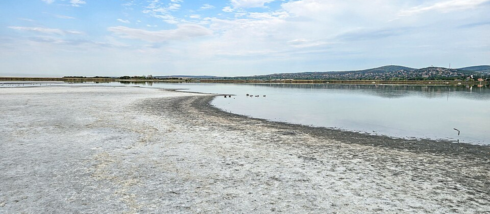
Lake Velence, 17 August 2026. Photo: Szilas / Wikimedia Commons, CC BY 4.0.
International Lessons: Engineering Capacity Cannot Solve Everything
The River Gediz in Türkiye is regulated by a valley-closing dam, a large reservoir and an irrigation system serving around 120,000 hectares. Despite this, in the summer of 2025 the river stopped flowing for kilometers along some reaches. The lesson is not that a dam automatically dries up a river, but that even a system equipped with reservoirs and water controls cannot meet unlimited demand. If irrigation demand and evaporation persistently exceed replenishment from the catchment, first the reservoir level and then the river's discharge collapse. This is also a warning for the Tisza: new irrigation programs based on the river can operate only while it and its tributaries genuinely have a surplus of water available for distribution. Even with the current, proportionally modest area of irrigated farmland, we are already approaching that limit.
The area around Dăbuleni in Romania is a sandy region similar to the Homokhátság, but with a more favourable, lower hydrogeographical position. In the 1970s, an irrigation system covering around 80,000 hectares was built using pumping stations, concrete-lined canals and terracing. After the political transition, operating costs became impossible to recover and much of the network ceased functioning. Utilization remained low even after refurbishment in the 2000s, and there were occasions when the crop could not be harvested economically despite substantial state support. The lesson is not that irrigation is inherently pointless, but that even the most advanced technical infrastructure cannot automatically make agriculture that works against the landscape's natural characteristics competitive. The planned replenishment of the Homokhátság would be an order of magnitude larger than the Dăbuleni system in both scale and energy demand.
Yet Hungarian grain produced with substantial EU subsidies already requires trade-protection measures against cheaper Ukrainian grain grown without EU subsidies. Adding the cost of irrigation would clearly make Hungarian arable farming even less competitive on the global market.
Directions for Solutions
When addressing water scarcity, the first instinct is often to increase surface water through more reservoirs, barrages and water-supply canals. These may be necessary for precisely defined tasks, but as a landscape-scale response to drought they can easily become a dead end and lead to the complete disappearance of water. The water present in a river is water that the soil and groundwater system were unable to retain. If those reserves have been depleted, artificially transferring surface water does not replenish the landscape. Shallow reservoirs with large surface areas have the greatest evaporation losses, while their meaningful effect in raising groundwater levels is confined to a shoreline strip only a few tens of meters wide.
Where the safety of settlements, topography and infrastructure permits, rivers must once again be allowed to spread over their former extensive floodplains. Instead of the narrow space between embankments, wider floodplains capable of shallow inundation are needed to slow flood waves, deposit sediment on the soil and allow infiltration across large areas.
Another practical measure could be to reconnect cut-off bends. Many of the nearly one hundred large meanders removed from the Tisza still exist as oxbow lakes. Because they did not deepen together with the main channel, they could function as natural channel sills: slowing the water, encouraging sediment deposition and reducing the river's drainage effect. Reconnection requires detailed hydrological, ecological and settlement-safety planning, and it is not possible for every oxbow lake. But it follows a different logic from building a new barrage: it uses the river's own forms instead of creating another evaporating surface. Many cut-off oxbows can be found not only along the Tisza but also along most of its tributaries, while opportunities for such intervention also exist at numerous locations on the Danube and its tributaries.
The lowland inland-drainage canal network must be transformed according to the same approach. Elements that are essential for protecting settlements and infrastructure must be maintained; those that cause the landscape to dry out persistently must be closed, made shallower or, preferably, backfilled. Water retention should not begin with pumping at the end of the canal, but where water seeps from the soil into the canal.
There Can Be No Transition Without the State
The necessary change cannot be expected from farmers alone. The current structure of land ownership, subsidy system and commodity market often actively encourage the continuation of water-intensive cultivation or practices poorly suited to the landscape. The state must:
- designate areas where arable farming cannot be continued economically and facilitate changes in cultivation methods
- establish a landholding structure better adapted to the landscape's natural characteristics;
- support cultivation methods that better enhance the soil's water-retention capacity and accumulation of organic matter
- eliminate or transform canals that drain water unnecessarily;
- replace tree plantations that are unsustainable on dry sites;
- restore room for grasslands, steppes and extensive grazing in the driest areas;
- compensate those who undertake periodic inundation, conversion to grassland or other forms of water-retaining land use;
- help farmers continue high-value production where the natural conditions genuinely support it.
- and use subsidies to facilitate the conversion of part of Hungary's high-value, internationally competitive agricultural production, such as horticulture, to enclosed, managed environments based on international examples.
This is a transition spanning decades, in which decisions on water management, agriculture, nature conservation, urban development and economic policy must all point in the same direction.
What Does All This Mean for Construction and Engineering Design?
The construction industry and engineering profession will have a highly significant role in resolving landscape-scale water scarcity. The built infrastructure of the future cannot be designed as though precipitation and groundwater were unlimited, unwanted by-products to be drained away. In settlements and developments, unnecessarily impermeable surfaces must be reduced, on-site infiltration increased, and greater use made of permeable paving, rain gardens, green roofs and blue-green infrastructure. When planning roads, bridges, industrial sites and residential areas, the entire catchment and expected changes in groundwater must also be taken into account.
What Can We Do Now?
The processes described above are slow and systemic. Nevertheless, farmers, property owners and industrial operators can already do a great deal to improve water retention on their own land and reduce their vulnerability to summer water scarcity.
For Farmers
- Aligning crop structure with site conditions – on sandy land, areas with low water-retention capacity or declining groundwater levels, it is worth reviewing whether the current crop can remain sustainable in the long term without irrigation and considering grassland management, extensive grazing or drought-tolerant varieties.
- Increasing soil organic matter – through green manure, cover crops, crop rotation and minimal soil disturbance, which directly improve infiltration and reduce irrigation demand.
- Continuous vegetation cover – stubble, catch crops and mulching to reduce evaporation from bare soil exposed to sun and wind.
- Improving irrigation efficiency – drip or micro-sprinkler technology, soil-moisture sensors and weather-based irrigation scheduling instead of wasteful open flooding.
- Small-scale water retention on the farm – restoring landscape-integrated depressions, marsh meadows and smaller areas capable of inundation, which retain water from wet periods on the property.
- Participation in water-retention and agri-environmental programs – these can provide long-term income security during the transition.
For Property Owners
- Reducing paved, impermeable surfaces on the property – using permeable paving blocks or crushed stone instead of fully sealed asphalt or concrete on driveways, terraces and parking areas.
- Creating a rain garden or infiltration swale – at points where rainwater runoff from roofs and paved surfaces collects, allowing it to infiltrate within the property.
- Rainwater harvesting – using a rainwater tank or cistern for garden irrigation, thereby reducing the summer burden on drinking-water resources.
- Green roofs or green space – on flat roofs where structurally and functionally feasible; these also reduce the urban heat-island effect and slow runoff.
- Native, drought-tolerant vegetation – instead of lawns and ornamental plants requiring intensive watering, particularly in lowland, sandy regions or areas with hot summers.
- For larger, continuous developments – blue-green infrastructure elements such as rain gardens, permeable paving and storage-based green spaces should be incorporated during the design phase, as retrofitting them is substantially more expensive.
For Industrial Facilities
- Water balance and water-risk assessment at catchment scale – not based solely on the facility's own well or abstraction permit, particularly at sites with high process-water consumption.
- Closed-loop or reduced-water-consumption cooling technology – instead of open evaporative cooling towers, where technically and economically feasible.
- Reusing industrial water and graywater – in technological processes, reducing the volume of freshwater abstraction.
- Stormwater management on site – collecting and storing runoff from roofs and parking areas for use in processes, irrigation or fire protection instead of discharging it immediately.
- Water security in investment decisions – when planning a new site or capacity expansion, considering the expected summer water resources of the local catchment rather than relying solely on current network capacity.
- Cooperation with regional water-management stakeholders – because a facility's water security ultimately depends on the condition of the entire catchment.
These individual measures cannot replace landscape-scale intervention at state level, but applied farm by farm, property by property and site by site, they can meaningfully reduce vulnerability.
Conclusion: We Need a Functioning Water Cycle
Climate change is aggravating water scarcity in Hungary, but the landscape's current vulnerability was created by a long historical process: straightening rivers, disconnecting floodplains, constructing the inland drainage canal network and converting an excessive share of land to arable farming. The ultimate fate and role of surface waters is loss: rivers carry water away, while lakes and reservoirs lose it through evaporation. There is no quick or simple solution. Reserves should therefore be created primarily in the soil, underground, on floodplains and through appropriate land use, where doing so is economical.
The 19th-century transformation of the landscape associated with István Széchenyi and Pál Vásárhelyi was a program of modernisation in its day. The 21st century requires thinking on the same scale, but in the opposite direction. Instead of removing more land from the natural movement of water, we must use intelligent engineering and ecological knowledge, underpinned by measurements and calculations, to restore the Hungarian landscape's ability to absorb and retain water.
We explored this approach in greater detail in an earlier article, from the sponge-city concept and rain gardens to blue roofs: The City as a Sponge – Engineering Responses and the Importance of Special Structures
Gábor Pál, Deputy CEO and Chief Financial Officer, CÉH zRt.